Live Chasing!

Saturday, May 2, 2015

April 1, 2015 Chase

Fun local chase.  Pretty structure near Springtown before the CAP killed off the storm.  Approximately 1" hail observed just west of Springtown.


Saturday, January 17, 2015

Hominy Tornado 4/14/11 revisited


What a day this was!  Marc and I sat in the northern suburbs of OKC awaiting initiation on what appeared to be a fairly potent severe weather setup later in the afternoon.  A line of scattered cells went up along the dryline that ran N-S along I-35. We chased the cells to the northeast and eventually found ourselves on a tornado-warned cell just to the south of Hominy, OK.  We gingerly positioned ourselves into the inflow notch of this beast as the RFD came racing in our direction.  Rain began to wrap around the low level circulation as the funnel quickly condensed into a wedge.  We bailed south and let the tornado pass about a 1/2 mile to our north.

Here is a screengrab just before we moved south.

Sunday, April 13, 2014

4/13/14 Forecast

Well, models are all over the place with what is going to happen later this afternoon and into tonight.  Here's an overview of what the latest hi-res model guidance suggests and some current trends:

13Z HRRR shows storms along dryline by 20Z


15Z run of Rapid Refresh model only shows storms along cold front by 0Z.  


The 12Z runs of 4km NAM/12km NAM/GFS didn't initiate convection along dryline either.  


So, what should we expect.  Tough to say.  Right now the mid-level jet max is moving across C TX and should aid in lift along the dryline.  Enhanced moisture convergence is noted just behind the dryline from Abilene and areas to the north.  Right now, TCU is showing up on satellite in that same area:

It appears we will have initiation in the next couple hours.  I believe the consistent cloud shield east of the 35 corridor will decrease severe storm chances in the near term for the metroplex.  Areas north of the cloud shield are seeing clear skies, increasing instability (SBCAPE >1500 J/kg), and good effective shear of 50-60 kts.  Let's hope that we see some stronger surface pressure falls over the area so that the winds don't veer in front of the dryline.

I leave work at around 3 with Daniel. 

Initial Target: Gainesville


Tuesday, April 1, 2014

4/1/14 quick forecast

HRRR and RAP continue to show initiation in the 5-6pm timeframe south of Wichita Falls.  Cu field developing just east of that area near the intersection of a dryline and cold front.

Both the 18Z RAP and 17 HRRR showing storms along dryline today.  Hope this verifies!

Hodos are quite elongated east of the dryline this evening.  Also, 40-50 kts of bulk shear should maintain supercell organization.  If storms can get rotating and fight the strengthening cap, then we should have quite the show this evening.  Or it could be a bust.  The atmosphere better not be playing a trick on us today!

Initial target: Wichita Falls


3/28/14 Chase

Quick summary for now.  Add more later.

Targeted Waco.  Left school by 1:30 because of early initiation.  Needed a bit stronger low level flow and a stronger CAP and this day would have been pretty good.  That being said, still jumped on a big HP supercell near the town of Rosebud, TX.  Got first decent gopro footage of a supercell!  Storm was struggling to contain its' cold pool.  There was a weakly rotating wall cloud that quickly became wrapped in rain.

Will post pics later.

3/15/14 Chase

Jumped on first storm near Stephenville.  Stayed on the storm a bit too long but did get some pretty good gopro video of the base of the storm.  Storm had weak RFD cut before it became outflow dominant.


Supercells formed along the dryline to to my SW during this time so I drove down 377 to intercept.  I was a bit late to get into position on the now SE moving supercells near Comanche.  I stopped between Dublin and Comanche and decided to set up shop on top of a hill.  

From a distance I observed a wall cloud beneath the dominant supercell.  It haven't purposefully hung that far back from the base of a supercell before.  Really got to witness the whole storm from NE of the base.  Very impressive!


On my way back through the town of Dublin, the sun began shining under the backside of the anvil and produced the most vivid double rainbow I have ever seen!  The picture doesn't do it justice.


Saturday, March 15, 2014

3/15/14 forecast

Well, I'm super pumped for this first setup of the season. It's not a great setup and low level flow will be fairly weak.  However, supercells are possible given 50-60 kts of 0-6 km shear and decent moisture return.     Low 60 dews creeping up to the Red River as of 1530Z:


A weakening lead shortwave will track across N TX and provide lift over a fairly diffuse dryline that will move west to east across C TX.

Both the 12Z runs of the RAP and the HRRR  show a weak meso-low develop near Abilene.   Sfc winds are weak but look to back a bit ahead of this low.


I'm going to play near this low if it materializes today.  Will be watching vis sat to see for breaks in the clouds.  If we can get some insolation today then MLCAPE's should reach 1000 J/kg.  This combined with the shear should give us rotating storms.  Whether they stay isolated may be the big question today.  There is a bit more of a cap today south of the metroplex.  Hopefully this will keep a grungefest from occurring.

I'm thinking we will see a QLCS form NW and W of the metroplex today and sweep through early this evening.  Storms should grow upscale and I'm looking for the tail-end charlie play today.

Wouldn't be surprised if I'm down near the Comanche - Waco area later today.

Great day to test the equipment!


Monday, November 4, 2013

May 31, 2013 - El Reno Tornado

An incredible and tragic day!  Incredible storm and tragic deaths of fellow chasers.

I began the day at school trying to wrap up our final day of teaching.  I knew that I would be chasing later that day since many ingredients were coming together for a localized outbreak of severe storms near the OKC area.  The SPC highlighted a moderate risk for severe weather across the state of Oklahoma along with a heightened risk of strong tornadoes.
SPC 17Z Categorical Graphic 

SPC 17Z Probabilistic Tornado Graphic


Had to wait for the final teacher meeting to end before I could meet up with Daniel Rodriguez.  I was running late and didn't arrive back home till after 2 pm.  We quickly packed up and hit the road for the OKC area.  Daniel would be behind the wheel while I navigated.


Before we reached OK, the SPC issued a PDS tornado watch:
"PRIMARY THREATS INCLUDE...
SEVERAL INTENSE TORNADOES LIKELY
NUMEROUS VERY LARGE HAIL EVENTS TO 4 INCHES IN DIAMETER LIKELY
NUMEROUS DAMAGING WIND GUSTS LIKELY WITH SEVERAL SIGNIFICANT
GUSTS TO 80 MPH POSSIBLE"


Agitated CU hinted at initiation soon just west of OKC by 2130Z.  We finally reached Hwy 9 and traveled west to Hwy 37.  As we were heading west on 37 we noted 3 main cells:
 0.5° Base Reflectivity @ 2257Z

I figured that the southern most cell would become dominant and we targeted this cell.  We made it into Minco and headed north on Hwy 81.  I wanted to position to the SE of the storm base so I told Daniel to turn west on Reno Rd.  I thought that the storm would track in an easterly fashion and at a chaseable rate of speed given what I saw on the special 18Z OKC sounding:
Note the extreme sfc CAPE (~5000 J/kg), low LCL, and Bunker's right storm motion vector of 260° @  21 kts!

Here is a map showing times and locations over the course of chasing what would be known as the El Reno tornado.


I began filming at 5:53:14 just west of Choctaw Ave.  The striated base was huge!  Without a doubt the most visually impressive storm that i had ever seen!
We couldn't make out the wall cloud yet.  We would eventually see it in a few minutes to our NW.  (© Daniel Rodriguez)


When we stopped at the intersection of S Airport Rd/Reno Rd at 5:58 pm, the rapidly rotating wall cloud was approximately 6-8 miles to our WNW.  I assumed that we were in good position if the wall cloud continued on it's easterly track.  We set up shop and began to film at 6:03:53 pm.  I had never witnessed such violent motion before!  
Filmed from S Airport Rd/Reno Rd intersection from 6:03:53-6:10:04 pm.
High Quality VIDEO


0.5° BR and SRV image @ 06:05:23 pm.  Our location denoted by white "X". 

Surprisingly, the tornado began tracking to the SE and eventually crossed Reno Rd about 2-3 miles to our west.  In hindsight, we should have repositioned then, but I still felt comfortable given the slower storm motion and grid road network.  I figured we could shoot east and then north or south depending on tornado track.  We stayed at that position and filmed until the rain curtains of the RFD began to near our position.  The tornado was barely visible at this time but looked to be quickly growing into a large stovepipe tornado (later analysis of video shows a giant wedge in progress).  Here are some screengrabs showing the tornado crossing Reno Rd:

Tornado N of Reno Rd  (Time: 6:05:08 pm)


Tornado crossing Reno Rd (Time: 6:08:02 pm)

Tornado S of Reno Rd (backlit by lightning; Time: 6:09:04 pm)
Note the tree being lofted in the air in foreground.

Wedge tornado SW (Time: 6:10:01 pm)
Look closely and note how quickly the tornado morphed into a large violent wedge!
0.5° BR and SRV image @ 06:09:57 pm.  Our location denoted by white "X".


As we traveled east on Reno Rd, we didn't encounter any traffic.  I knew we had to quickly head east but was not that worried at the time.  I figured we would quickly outpace the tornado as we traveled east.  However, as I was peering out the side window I was amazed at how quickly the tornado was increasing in size by the time we were near Choctaw Ave (6:16:02 pm).  At that time, I noticed wrapping rain curtains no more than a mile to the southwest of us.  Also, it appeared that the tornado had shifted back to the north a bit and the center was closer to our 5 o'clock.

We continued east about another mile and were nearing our main N-S paved road option Highway 81.  We were approximately a 1/4 mile west of 81 and trees on the side of the road were making it difficult to see the tornado.  What I did notice between the trees was that the tornado had shifted a bit to the south again.  I was able to take some more short footage of the tornado.  Large subvortices were moving around the main circulation center.

About 1/4 mile west of Hwy 81.  Filmed from 6:16:33-6:17:26 pm.
High Quality VIDEO

When we reached Hwy 81, we were stuck behind at least 5 cars that obviously didn't know how dire the situation was at the moment.  It was obvious that we weren't going to be able to head south and beat the tornado, so I told Daniel to continue heading east.  In hindsight, we should probably have headed north.  However, I didn't want to get caught in the core and risk not seeing a tornado coming at us.  I saw clearing to our east and so that's where we went.   Daniel drove around the line of vehicles and we crossed 81.

We traveled no further than a 1/4 mile and I began videotaping what I thought was possibly the main tornado.  It was a violently rotating stovepipe-shaped tornado and was heading quickly in our direction.  I couldn't believe how quickly it was moving and was amazed at how fast it was closing on us (later analysis revealed that MVMC had accelerated to over 50 mph to the east!!). I told Daniel that "we have to get out of here!".  I could see the inflow jet just to our south and the tornado was crossing Hwy 81 no more than a mile to our southwest.  I'm pretty sure what I filmed was the exact moment that the Weather Channel chase truck was hit.  Later on, I found out that this tornado was one of several subvortices moving around the main tornado (which had now grown to 2.6 miles wide!).  These subvortices were moving at up to 150 mph within the parent tornadic circulation!

Filmed from Reno Rd, just east of Hwy 81 from 06:18:42-06:19:10 pm.
High Quality VIDEO

0.5° BR and SRV image @ 06:19:11 pm.  Our location denoted by white "X".  

We were quickly engulfed by the 100+ mph winds of the inflow jet and Daniel struggled to keep my truck on the road.  Visibility was near zero at times and Daniel was using the line of trees on either side of the road to center himself so that we wouldn't go into the ditch.  Even though Daniel had the pedal to the medal, we were only able to go 40 mph or so.  We weren't gaining much ground on the tornado.  Within a minute, the rear passenger window blew out on my truck and the Davis weather station was removed from my roof.  This was near the Reno Rd/Alfadale Rd intersection.  I believe that we were sideswiped by the inflow jet of the large subvortex that hit The Weather Channel truck.  The next couple minutes were the scariest of my life.  I just held on and hoped that Daniel could keep us on the road.  We continued on within the inflow jet hoping that we wouldn't get rolled over.  Thankfully, the tornado shifted to the north of Reno Rd and began tracking towards I-40.

Josh Wurman, Karen Kosiba, Paul Robinson, and Tim Marshall have put together an excellent research paper on the El Reno tornado.  Here is a detailed graphic showing the track of the tornado/MVMC:


The black "X" represents the Reno Rd/Alfadale Rd intersection.
As we cleared the strong inflow about 2 miles west of Banner Rd (our next paved N-S road option), I felt confident that we were safe.  We turned south onto Banner Rd and started shooting video.  Strong 60+ mph RFD winds began to slam us from the west and destroyed an old wooden barn a couple hundred feet to our south.  So we quickly shot south and got out to film the massive wedge and its' subvortices.  Unbelievably, it appeared that the entire mesocyclone had dropped to the ground!  You could hear the audible roar of the tornado from several miles away!  It was surreal!  We also observed a small mid level funnel along the rfd gust front.  It lasted for less than a minute.


Filmed just south of Reno Rd/Banner Rd intersection from 6:24:52-6:29:34 pm.
High Quality VIDEO

The tornado eventually became rain wrapped and was very difficult to see.  We planned to reposition for another supercell that was developing to the west of El Reno.  We headed south and and west back to Hwy 81.  We found ourselves stuck in a huge traffic jam with an approaching mesocyclone from the west.  We eventually crossed the Canadian river and headed to Minco.  We positioned on the west side of Minco and filmed a large wall cloud to the NW of town.  Eventually the storm became outflow dominant and we headed home.


Tragically, Tim Samaras, his son Paul, and Carl Young of the TWISTEX team were killed by the tornado near the intersection of Reuter Rd and Radio Rd.  My heart goes out to his family and for others that were directly affected by this event.

Major kudos to Daniel for staying calm and driving us to safety.  Unfortunately for Tim, Paul, and Carl this beast shifted quickly to the northeast.  However, that shift in its' track probably saved our lives.

Damage to truck from tornado


Wednesday, April 25, 2012

April 3, 2012 chase

This was definitely a surprise chase day for me. 

Synoptic environment:
A compact upper level low was spinning over NM by 12Z and the associated 500mb low was progged to move slowly NE throughout the day. 

A 60kt jet streak was located at the base of the 500mb low and was forecast to move over the N TX area during the early afternoon. 
Note the SW 55kt flow at DFW.

The upper level low moved N throughout the day and we actually had southerly 55 kt flow by 00Z. 

850mb flow was southerly and around 25-30 kts. 

At the surface, there was appreciable moisture with dewpoints in the upper 60's.  Winds were ESE at around 5-10 kts. 

There was a definite outflow boundary from previous night's convection in OK that was making it's way south.  Notice the easterly and northeasterly winds running roughly along a line from DFW area to Texarkana.  I noticed this in the morning and it was plain as day on vis satellite.  I didn't know at the time that this would help to contribute to the mini-tornado outbreak that I was to commence later in the afternoon.

A line of elevated storms had already developed along the dryline in western North Texas and was making a slow progression to the east.  I decided, after getting back from the doctor's office, that I would go out west and do a test run with the video stream.  Although there were some breaks in the cloud cover to the east of the line of storms, I didn't think that discrete convection would fire around the metroplex so I headed west to Weatherford.  I set up at a truck stop along I-20 and started streaming the rotating, yet elevated, storm that was moving into that area.  I messed around with that storm for about 15 minutes until I noticed a cell developing south of the metroplex and ahead of the main line.  I quickly jetted east on I-20 and by the time I had reached western parts of Fort Worth, the storm became tornado warned.  I figured that I would be able to intercept somewhere east of I-35 and eventually made my way into the strong winds and heavy rain of the FFD around the Kennedale area.  I knew that the meso had to be to my south because of the northerly winds.  When I got into the clearing in the bear's cage, I turned off onto Little Rd near the I-20/287 interchange.  As I made my way down the road I caught the first glimpse of the tornado.

I headed to the on ramp of 287 and stopped to set up.  The tornado was less than a mile to my SW and I was able to get out and make a quick judgement call that the tornado was going to move just to my south. 

What commenced was the best footage of my life:


The tornado passed 1/2 mile to my south and displayed varying shapes (cone/stovepipe, multi-vortex, no condensation funnel, ragged tube) as it moved to the northeast.  This is the first time that I have seen multiple vortices up close and personal.  Pretty interesting how it did that while on the highway.  I couldn't believe cars weren't bailing out of there.  I don't think some of them knew what was actually going on or didn't realize the situation until it was upon them.

The descending RFD was a pretty dramatic sight.  When you get this close you really lose sight of the massive wall cloud over your head.  After losing sight of the tornado, I quickly drove down to the place where the tornado crossed and turned around.  I snapped a few photos of the damage.


 The tornado continued into the Arlington area causing EF-2 damage.

I drove back to I-20 and headed east to see the tornado roping out. 


I was quite worried because my wife was working at a nursing home in the Euless/Bedford area and the meso was heading in her direction and still showing strong rotation.  After calling and warning her about the incoming storm, I headed east and then north to reposition on the storm.  I wasn't able to get another good vantage point of the base of the wall cloud, but I did get a few structure shots of the meso with a beautiful RFD cut. 


Called it a day to the east of DFW airport at around 2:00 pm.  This was the earliest that I had returned home from a successful intercept! 

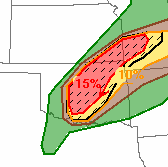
Here are the storm reports for that day:

Radar image of supercell at approximate time of my footage:
Kennedale/Arlington Tornado
www.srh.noaa.gov/fwd


Monday, April 2, 2012

4/2/12

I've been watching this system evolve over the past couple days and haven't posted about it.  The closed 500mb low is currently over NM and an attendant 90kt jet streak is rounding the base of the low.  The position of the low is far west of the dryline placement today, which is located roughly from Canadian-Childress-SW TX with a slight bulging near the Red River.  This morning the WRF 4km models were showing CI occurring around 23-0Z from far Western OK down to just a couple counties west of Fort Worth.  The HRRR was also showing CI closer to the SPS area.  The problem I'm seeing right now is that it looks like the thin layer of moisture (around 100mb deep) is being mixed out ahead of the dryline south of Childress.  This could make it harder for CU to break through the cap to the west of Fort Worth.  Now, the HRRR is only showing CI in Western OK closer to the surface low. 
abi METAR plot

If storms can fire, they will become severe very quickly with MLCAPE values AOA 3000 J/kg.  If storms can remain discrete, I believe that as the upper level support increases from the west and bulk shear values increase AOA 40kt, then we can get some massive HP supercells with few reports of weak tornadoes.  If I were positioning today, I would be parked in Altus, OK (where a cu field is developing) and watch to see which storm becomes dominant.  The slow storm speeds today should make for easy viewing of the storms.  Structure shots will be a premium today! 

I will be sitting at home tonight watching KU try for another basketball championship.  GO JAYHAWKS!!