Live Chasing!

Wednesday, May 25, 2011

5/24/11 Chase

Very disappointing chase!  Left Fort Worth around 12:30 and headed north to Gainesville.  Noticed that a large cu field was already developing (earlier than thought) in SW OK by 19Z and figured that we better head W on 82 towards the SPS area.  We came up to US81 and headed north towards Waurika.  Waited there for a while while storms were firing north along I-40 in WC OK.  We stayed put hoping that other storms to the south would fire and move in our direction.  In retrospect, we should have headed N and positioned for storms as 2 tornadic supercells were dropping large tornadoes north of us.  We eventually hopped on the storm that eventually produced the Dibble tornado.  We played catch-up the entire time.  Partly my fault for waiting to long to intercept and aided by the 50mph NE storm motions, we never were able to see the tornado.  I also made a terrible decision in Lindsay to head west for a mile and then north to view the tornado.  The storm was moving so fast that we fell behind it and then had to move north to Dibble and then east.  We passed two damage paths.  From what I saw, damage was at least EF3 and the path was probably 1/4 mile or wider.  It was the most intense damage that I have ever witnessed before.  I will never forget the smell of the fresh pine from all the snapped trees and the completely destroyed homes with families all huddled together in shock.  I will upload some images when I get a chance. 

We made it to Purcell and decided to head south to intercept a storm headed for Pauls Valley.  Never made it in time but saw a mid-level funnel from the weakened storm along I-35.  More storms were to the south, so we continued heading south into Ardmore and followed another tornadic storm through town.  After playing around in the rain curtains of the RFD for about 15 minutes, we headed back to 35 and decided to just head for home.  For the remainder of the drive, we had to witness several supercells just to the east of 35.  It was excruciating to see these rock-hard updrafts and know that we werent able to intercept because we were too late.  Brought back memories of 4/14/11. 

When we made it into the DFW area, we noticed an incredibly structured supercell directly to our south in the Benbrook area.  It had an incredible back-sheared anvil and continuous lightning illuminating the updraft.  It was about 9pm, but we decided to intercept.  We headed around the east loop of 820 and intercepted the storm near the intersection of I-20.  Followed it east and witnessed a large wall cloud and funnel but the RFD eventually wrapped around the meso and we were forced to stop the chase.  We made it home around 11:30.

So, to sum it up.  An 11 hour chase with several intercepts of tornado-warned cells and 0 tornadoes.  It was an epic fail in that regard.  However, I learned a lot about chasing on these "major outbreak" days.  Position well to the NE and get on the first storms that fire if you can.  If you play it right, you can drop off and get the next NE moving storm coming your way.  It lloks like several veteran chasers did that and I definitely won't make that mistake again.  Also, I need to make sure that I don't become so radar-dependant.  I found myself treating the updated radar images as they were in real time with respect to the storm.  This put us out of position near Lindsay as I went against my gut and headed west instead of east.  If I would have just went with my original plan, we would have had one hell of an intercept of the Dibble-Washington-Goldsby long track strong tornado from close range! 

As Marc put it well........"Shoulda gone east!"

Oh well.  There will be more tornadoes to chase soon :)

Here are the reports from today:

Saturday, May 21, 2011

5/21/11 Reading tornado

Looks like a tornado caused damage in Reading, KS.  The tornadic supercell had a strong velocity couplet and a noted BWER directly over the city.  Here are a couple screengrabs from GR3:


I'm sure that some damage photos will pop up tomorrow.  Interesting to see how strong this tornado was.

5/21/11 Storms

Looks like today will be another active severe weather day for parts of North Texas.  Right now, storms have fired off of a well delineated N-S dryline. 
LUD is 84/70 while RPH is 95/28!

The right entrance region of a 50kt H5 jet streak is over the area and is helping parcels lift to their LFC's.  MLLCL's are 3500+ J/kg and 0-1 SRH values will increase as the afternoon wears on.  Could see a tornado report from one of these storms as the night continues.
Looks like the first tornado warning of the day just issued for storm near Evant!


Thursday, May 19, 2011

5/19/11

Well, convection has fired in SW OK along the dryline.  Here is the screengrab from GR3 at 19Z:

Unfortunately I won't be able to make it up there tonight due to work but I'm hoping to catch some tubes on the streams. 

Models did well with dryline placement; not too well with convection though.  I think the HRRR showed precip firing a little earlier than this closer to the SPS area.  The storms are all rotating and are moving NE into a good environment.  The dews are in the middle 60's with even 70 dews creeping up from SC OK.  Backed sfc flow of 20+ kts and MLCAPE values of over 2500 J/kg, also LCL's below 1200 m all look enticing.  0-1 km shear is pretty weak (10-15 kt) but the environment to the NE of these does get better and the SPC's mesoanalysis shows 0-1 SRH values of 150 in WC and NW OK.  The northern-most storm may be the good play at this point if these all stay discrete over time.

We will see.

Tuesday, May 17, 2011

Need to refocus

Haven't posted in a while.  Been extremely busy with school stuff and field trips and along with an active April season, i haven't posted chase reports nor posted anything else.  So, with potential chase days this week, I better get refocused and get back into the forecast mindset!  I will have the opportunity to chase both on the 19th and 20th. 

It's 3Z, Wednesday the 18th and here's the synoptic breakdown:


Strong H5 trough along west coast.  Will slowly make way towards plains over next couple days.

For Thursday the 19th.  Here are the model differences as of 18Z models.

By 18Z, the 19th, the GFS is a bit deeper with H5 low and places 70kt jet streak along W TX and OK panhandles.  The GFS is also showing a bit more meridional component to the flow and is a bit east of the NAM jet streak placement.

With the deeper H5 low solution of the GFS, a deeper H85 low is also shown.  Flow is near 20kt wwith a strong southerly component (S or SSW).  The GFS continues to deepen H85 low and thus strengthens flow to around 30-35kt. NAM is warmer with temps and also mixes these down to surface.

NAM places broad 997mb sfc low in SE CO.  A warm front extends east through SW KS and looks to not move through 0Z.  Temp gradient is strong with 60's to north and 80's to south of front.  GFS has stronger 994mb low in E CO with WF in N KS.  Also looks like GFS places meso low in SW KS by 0Z.

Dryline placement similar and placed from Hutchinson down through Wichita Falls with mid 60 dews east of line.  Backed sfc flow looks enticing on both models.  Temps in warm sector in the mid 70's on GFS and mid 80's on NAM.  If GFS is to be believed, then LCL's look good < 1000m.

Will analyze models tomorrow, but the GFS solution looks good but it has tended stronger all season long only to putter out the day before.  I believe it has showed run to run consistency though this time.  The 700-500mb lapse rates are not strong at all and I wonder what is causing this.  Other than that, I wouldn't be surprised to see a good chance for a couple tornadoes in SW OK near the LAW area and to the north.  Better shear exists north along the dryline, but I want to stay south due to work restrictions and better moisture and cape profiles. 

Thursday, April 21, 2011

4/21/2011 Chase

Well, had to pick up some nasonex for Ayden over in Benbrook and then I headed west on I-20.  Took 180 towards Mineral Wells and got there around 5:30.  Decent cu field began to disintigrate over the next hour.  The cap was just strong enough today.  The warm front became diffuse and the sfc convergence was not strong enough to get things going in N TX.  I thought that being a bit west might help if we received some subtle upper level support.  Didn't happen.  Decided to head home around 6:30. 

Taking a look at the FWD 00Z sounding:

Just enough cap today to keep storms from firing.  CIN of -51 J/kg.  Frustrating because it looked like a decent tornado chance today if storms were to fire along the warm front.  First cap bust of 2011!


A supercell did fire just west of Abilene though.  It was a beast and probably had a rain-wrapped tornado at one point.  Here is a screen grab from GRLevel3:

April 21, 2011 chase forecast

I noticed a couple days ago that there was some potential for storms along the retreating warm front on Thursday.  After coming back to school from a severe weather protocol session, I started musing over data.  I think there is potential for a few reports of tornadoes along the warm front today.  Right now, 20Z, the warm front is along a BWD-ACT-JSD line.  The warm front will continue north through the night and winds are backing up along the warm front.  The area north of the front has been socked in with clouds all day and temperature readings as of 20Z are in the mid 60's.  South of the front temps are running in the low 80's.  Low level shear should be enought to get some low level mesos going with any storm that becomes mature.  With the cap becoming negligible in the next hour or so and with convective temps being reached, I'm afraid that lots of storms will be competing at first.  A pretty robust cu field is moving north along the aforementioned line.  I will monitor trends over the next hour and probably make my way south to get out of the metroplex.  Whether I go east or west from there will be the next choice.

SPC's has 5% tornado probability over the area.

Wednesday, April 13, 2011

4/14/11 forecast

Well, tomorrow's forecast is a bit tricky.  The main components are set in place for a possible tornado outbreak over SE KS, NE OK, and E OK.  The NAM and GFS agree on a few things:

- negatively tilted H5 trough with westerly jet max nudging in at time of peak heating
- sfc moisture return into warm sector with low to mid 60's Td's nosing into NE OK by 00Z
- Dryline from triple point near KICT draped south along I-35 corridor with associated bulge in N OK
- Cape values aoa 2000 J/kg
- reduced CIN inv of dryline along I-35 corridor from KICT down to red river area
- both are closing off the H5 low.  The GFS the more active one
- Low LCL's aob 1250m

The GFS is closing the H5 low and this is causing veering flow patterns in the low levels along I-35.  This is not boding well for tornadic storms.   The better directional shear will be in the far eastern sections of the warm sector.  If the GFS does verify, storms will struggle to develop low level circulations until they move into better wind fields in E OK/W AR.

The NAM is not closing the H5 low as much and the low level wind fields look much better.  H85 winds are still southerly inv of dryline.  This is contributing to larger clockwise curved hodographs, especially as the llj strengthens into the early evening in E OK.  Sfc flow doesn't back as much along the dryline.  That's a little concerning but I think that if storms do fire along the dryline, they should mature and develop better rotation into the eastern section of the warm sector.

I'm hoping that the NAM doesn't continue to veer the low level winds as the GFS is doing.  I will probably head towards OKC tomorrow morning and reevaluate the mesoscale conditions around 18Z. 


Also, just checked the 00Z 4km WRF model and it looks quite enticing for supercells to form in C OK by 23-00Z and then into S OK a couple hours later. 


Simulated Radar Reflectivity


2-5km maximum updraft helicity

Monday, March 21, 2011

March 8, 2011 Chase

The Day Before
A couple days before the event, I noticed that there would be a marginal chance at a severe weather event in North Texas on March 8th.  The NAM continued to show a strong surface low moving E through Central OK that was dragging a dryline east through N TX by 21Z (Tuesday 3/8).  The dryline looked to be from a Sherman-McKinney-Dallas line by 0Z.  Ahead of the dryline, the warm sector was characterized by westerly H50 winds of 50 kts, southwesterly H85 winds of 25-30 kts, and surface winds backing from the south-southeast at 5-15 kts.  These winds provided adequate directional and speed shear for supercells ahead of the dryline.  The 0-6km storm motion vectors were nearly orthoganal to the orientation of the dryline which suggested a potential for discrete supercells!  Storm motions looked to be to the east at 35-40 kts which would be manageable if storms were able to fire along the I-35 corridor and mature before the Sherman-Paris area (areas further east of Paris don't have favorable terrain for viewing storms).  SBCAPE values looked to be around 1000-1500 at 0Z in that same area.  Definitely sufficient enough for vigourous updrafts.  3km SREH values of 150-300 and 1km SREH values of 100-200 indicated a potential for rotating updrafts and tornado potential with strong 0-1km wind shear values.  Moisture didn't look like too much of a problem with 60+ dews spreading N towards a warm front that was draped just south of the Red River by 0Z.  The NAM was showing that CIN would be reduced enough to fire convection along the I-35 corridor by 21Z.  Given these numbers and the fact that there was a pretty decent chance that when convection developed that a tornado threat was possible, I decided to call a sub and take the day off of work.  The first storm chase of the day was less than 24 hours away!!!!

Morning Analysis - Chase Day
When I awoke the morning of the 8th, I looked at the 12Z upper air analysis.

 250mb
100 kt jet max over AZ and NM about to round base of trough and eject into Southern Plains.


 500mb
60kt jet over west TX!

 700mb
45kt over west TX

 850mb
Strong 40kt low level jet.  Didn't like to see winds veering a bit though.  Good fetch of moisture into N and NE TX.


The 12Z FWD observed sounding
Notice the large clockwise curvature of the hodograph. 3-6km lapse rates are pretty steep.  With increased sfc dews and temps, and continued mid-level cooling the cap should be eliminated by early afternoon!


Looking at surface observations:
12Z
Deep moisture in central TX (64 dewpoint).  Strong backing winds.
  Dryline located in eastern TX panhandle.  Very dry air in the Big Bend Country (note the dewpoint of 17).


After checking the morning analysis, I reviewed the RUC and it was in general agreement with the NAM about dryline position and environmental conditions for the afternoon.  It showed convection firing along I-35 corridor between Gainesville and Denton.  The 4km WRF reflectivity image also showed convection firing around the same time and location.  With convection firing pretty early, I knew that I would have to get out of the house around 17Z so that I could make it into the target area early.  I've been burned before by being in position too late.  Best to be early and make decisions from your taget area then to play catch up (especially when you are chasing alone!).  AFter stopping by Best Buy to pick up a 16GB SD card, I made my way out of Fort Worth by 1730Z.

The SPC's 1630 convective outlook showed a pretty large Slight risk area over N and NE TX.  Tornado probabilities were 5% up near the Red River and east of Sherman, TX. 
You can see that the western edge of the Slight risk area is approximately where the SPC forecasters believed convection would fire along the dryline.

Here is the wording from the 1630 outlook:
SPC AC 081625 
DAY 1 CONVECTIVE OUTLOOK 
NWS STORM PREDICTION CENTER NORMAN OK 
1025 AM CST TUE MAR 08 2011 
VALID 081630Z - 091200Z 

...THERE IS A MDT RISK OF SVR TSTMS PARTS OF LA AND SRN MS... 

...THERE IS A SLGT RISK OF SVR TSTMS FROM PORTIONS OF EAST TX/OK 
INTO THE LOWER MS VALLEY... 

...SYNOPSIS... 
LARGE SCALE TROUGH SHIFTS EWD ACROSS PLAINS THRU THE FORECAST 
PERIOD. ONE S/WV NOW ROTATING NEWD THRU KS/NRN OK WHILE UPSTREAM 
VORT MAX CENTRAL NM MOVES EWD ACROSS SRN PLAINS TO LOWER MS VALLEY 
12Z WED. 
IMPRESSIVE MOISTURE STREAMING NWD FROM WRN GULF INTO SRN PLAINS AND 
LOWER MS VALLEY THRU THIS EVENING AS A WARM FRONT DEVELOPS INLAND 
ACROSS SERN TX EWD INTO SRN MS BY LATER THIS AFTERNOON. STEEP MID 
LEVEL LAPSE RATES HAVE SPREAD EWD ACROSS SRN PLAINS INTO LOWER MS 
VALLEY THIS MORNING ATOP THE DEEPENING LOW LEVEL MOISTURE AS 
DEWPOINTS RISE THRU THE 60S BY THIS AFTERNOON ACROSS LWR MS VALLEY. 
..LA/MS LATER THIS AFTERNOON AND TONIGHT... 
THE FOCUSING MECHANISMS FOR CONVECTIVE DEVELOPMENT REMAIN A QUESTION 
ATTM HOWEVER A WEAK CAPPING INVERSION AND INCREASING LARGE SCALE 
FORCING ARE EXPECTED TO RESULT IN SCATTERED DISCRETE THUNDERSTORM 
DEVELOPMENT IN A RATHER STRONGLY SHEARED ENVIRONMENT. FORECAST 
SOUNDINGS SUGGEST EFFECTIVE SHEAR VALUES OF 40-50 KNOTS AND 0-3KM 
SRH OF 250-350 M2/S2. WITH LARGE SCALE ASCENT INCREASING BOTH DUE TO 
CONTINUED WARM ADVECTION AND APPROACH OF THE NM IMPULSE AND 
MID/UPPER LEVEL WIND MAX... DISCRETE THUNDERSTORM DEVELOPMENT 
APPEARS LIKELY BY LATER THIS AFTERNOON AND EVENING VICINITY OF THE 
WARM FRONT MOVING INLAND ACROSS LA AND SRN MS. GIVEN THAT MLCAPES 
INCREASE TO 1500 J/KG AND FAVORABLE SHEAR ENVIRONMENT NOW IN PLACE 
WILL JUST IMPROVE THRU THE AFTERNOON...THE THREAT OF SUPERCELLS 
DEVELOPING INCLUDING TORNADOES ARE LIKELY BEGINNING BY LATE THIS 
AFTERNOON AND CONTINUING TONIGHT ACROSS LA INTO SRN MS. THERE IS 
THE RISK OF STRONG TORNADOES. UPSCALE ORGANIZATION INTO BOWS/LEWPS 
IS POSSIBLE OVERNIGHT WITH THE POTENTIAL FOR DAMAGING WINDS 
SPREADING EWD INTO WRN AL. 
PORTION OF THIS AREA HAS BEEN UPGRADED TO A MDT RISK DUE TO THE 
GREATER CONFIDENCE OF THE POTENTIAL FOR STRONG TORNADOS. 

...OK/TX/AR/LA... 
BY LATER THIS AFTERNOON...THE SURFACE DRYLINE WILL SURGE EASTWARD 
INTO EAST-CENTRAL OK AND CENTRAL TX. MODELS STILL DIFFER ON THE 
EXTENT OF CONVECTIVE DEVELOPMENT ALONG THE BOUNDARY...BUT SUFFICIENT 
RISK IS PRESENT TO MAINTAIN SLIGHT RISK ALONG THIS CORRIDOR. THOSE 
STORMS THAT DO DEVELOP WILL POSE A THREAT OF LARGE HAIL... DAMAGING 
WINDS...AND EVEN ISOLATED TORNADOES. IT APPEARS THE MOST LIKELY 
AREA FOR THUNDERSTORMS ALONG THE DRYLINE WILL BE ALONG AND 
IMMEDIATELY SOUTH OF THE RED RIVER LATER TODAY. THESE STORMS WILL 
SPREAD EASTWARD INTO PORTIONS OF AR/LA THIS EVENING WITH A CONTINUED 
SEVERE THREAT. 
..HALES/GRAMS.. 03/08/2011

The Chase
On my way to Gainesville, I noticed several updrafts that were struggling with the strong speed shear and what was left of the cap. 

At 1930Z, the first storm became visible on radar.

By 2117Z, one storm became dominant and had developed mid-level rotation. 


Dominant storm near Whitewright, TX
Storm just beginning to develop an inflow notch.

This storm would track east along and just north of Highway 82.  It was HP for all of it's life.  As the storm moved toward Sherman, I made the biggest mistake of the chase.  I traveled south of Highway 75 to meet up with the updraft of the not-yet severe warned storm.  At the time, the storms were semi-discrete but were forming into line segments.  Remember, always stay well east of these storms and let them come to you.  I was a over-anxious and wanted to be near the updraft early in the storm's development.  Will try not to make that mistake again this season!  Anyways, I headed south to Highway 11 and made my way towards the city of Randolph, TX.  Then I headed NE on Highway 121 towards Bonham in hopes of getting out in front of the core of the main storm.


Video of 1st bad decision of the day

Video of that updraft (got blasted by RFD after updraft moved past me)  Quite intense!


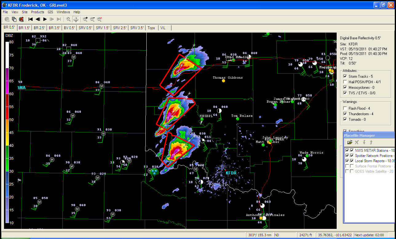
As I made my way into Bonham, I found myself on the back side of the storm in the RFD.  I jumped onto Highway 82 and did my best to get out in front of the storm.  Strong north winds around 50 miles per hour, extremely heavy rain, and pea to quarter size hail were pounding the driver's side of my car until I was able to break free into the clear slot near the city of Toco, TX.  At one point during this venture, I was afraid that I would drive into the back side of a rain-wrapped tornado.  When I made it into Paris, TX I headed south on loop 286 and after traveling a mile or so I noticed what looked like a small area along the RFD front that exhibited strong rising motion (almost like a weak funnel).  It lasted about 20 seconds.  Don't know if it was a gustnado or maybe the roping out of a tornado.  SPC reported damage from a weak tornado near the city of Brookston, TX.  This would have been near the location that I was looking at.  Very interesting to say the least.  Here is a radar grab at the time I saw the feature:

Reflectivity
Storm is 100 miles from radar and the 0.5 tilt is displaying reflectivity at about 11000 ft.


Storm-Relative Velocity


I sat at the intersection of loop 286 and Farm to Market Road 137 for a few minutes and faced north to get video of strong inflow into the meso of the storm.  Here is what I saw:


I continued along loop 286 till I reached the intersection of Highway 271.  I stopped to get video.  The storm was tornado warned at this point and about to make it's way into the city of Paris.  Siren's were blaring in the city.  Rapidly moving cloud tags (assuming this was the tail cloud) were streaming into the meso at this time.  Here is a video of what I saw at the time:


This is the point where I made my second bad decision of the chase and that was to sit too long at that intersection instead of heading north to Highway 82 and get east of this storm.  For some reason I was afraid that I would move north onto 82 and get hit by the 2-3 inch hail that this baby was dropping.  The storm was turning right and heading slightly south across 82 and I thought I wouldn't get to the highway by the time the soon to be tornado would drop out of this storm.  The storm was still HP and the meso was wrapped  with rain.  The tornado would have been difficult to see if it had dropped near Paris.  So, I decided to head SE on 271 to Airport Road and then head east a mile or so to get back to 82.  Big mistake!  The storm caught up to me and I decided to allow the RFD to blast through.  After that, I was on the back side of the storm and didn't have a good east road option to get out ahead of the storm again.  Plus, now the storm was about to put down a tornado and I didn't want to take the risk being by myself.  So, I ended the chase near the airport. 


As the storm continued to head east, it did drop two other tornadoes.  One developed into a wedge near the city of Clarksville, TX and traveled into the north side of the city.  I believe that it did F1 damage.  A few chasers got some great video of this wedge.


So, I ended my chase around 5pm and began my way home.  I am pretty satisfied with my chase overall.  I forecasted the area of initiation well and was able to get out ahead of this HP.  For being by myself, I thought I made pretty good road decisions except for the two that I discussed earlier.  I didn't get video of the rotating feature near Bonham, but I have a feeling that I may have seen the ending of that tornado. 

Lessons learned today.............Stay well out ahead of the storm and let it move toward you.  If you are chasing alone, be more aware of your road options before you make a rash decision to move.  Stay near any warm front if storms are moving near it.


Here are the SPC reports for the day.  Note the cluster of reports from the storm I was on in NE TX.

Tornado Reports (CSV) (Raw Tornado CSV)(?)
TimeLocationCountyStateLatLonComments
2215BROOKSTON LAMAR TX33629570AT LEAST TWO LAW ENFORCEMENT OFFICIALS REPORTED A BRIEF TORNADO TOUCHDOWN SOUTHWEST OF BROOKSTON. AT LEAST ONE BARN WAS DAMAGED. TIME WAS BETWEEN 410 PM AND 415 PM. (FWD)
23158 W CLARKSVILLE RED RIVER TX33619519AN EF1 TORNADO TOUCHED DOWN ABOUT 8 MILES WEST OF CLARKSVILLE TEXAS ... AND MOVED EAST NORTHEAST TO A POINT ABOUT 3 MILES EAST NORTHEAST OF CLARKSVILLE. DAMAGE PATH WAS 1 (SHV)
23204 E DETROIT RED RIVER TX33669520CHASERS CONFIRMED RAIN WRAPPED TORNADO ON THE GROUND NEAR BAGWELL..EAST OF DETROIT ALONG US 82 (SHV)
23302 N CLARKSVILLE RED RIVER TX33649506CHASERS AND SPOTTERS CONFIRM TORNADO ON THE GROUND ... RAIN WRAPPED. SEMI ON A CAR ... TRAILERS FLIPPED ... POWERLINES DOWN ... MANY ROOFS DAMAGED TO HOMES. (SHV)

Saturday, February 5, 2011

February winter storm Feb 1-4

We had a very intense mid-level shortwave eject through North Texas last Tuesday (Feb 1) and we received about 1-1.5" of sleet in my area (NW Fort Worth).  After the vort max passed through, it dragged a very strong cold front behind it.  Temperatures plunged from the 50's pre-front to the 20's post-frontal.  On top of the sleet, we also received about an inch of snow.  The storm lifted to the northeast and dumped snow of over a foot throughout areas from Oklahoma to Chicago. 

The frozen precip pretty much shut down all of the DFW metroplex.  All area ISD's shut down and travel on all roads was dangerous.  Cloudy skies that hung around for several days helped little with melting of the ice.  That which did melt/sublimate just refroze overnight, making driving the next morning impossible in some locations.  Ft. Worth ISD and all private schools (including the school I teach for.....Fort Worth Academy) shut down for the remainder of the week.  Yeah!!

To make matters worse, another shortwave moved from SW TX and over our area Thursday night (2/3/11) and dumped anywhere from 1-6" of snow across the DFW metroplex.  Here is a link LINK to a map of snowfall storm reports across the area. 

It is now Saturday (2/5/11) and the sun is out in full today.  We warmed up above the freezing mark at around 10 am this morning.  This marks a period of 103 hours of below freezing weather over at DFW airport.  Here is what the NWS FTW posted about the cold snap:
"10 AM observation at DFW was above freezing. This was the first time the temperature was above freezing since 3 AM Tuesday, resulting in 103 total hours below freezing. This is the longest streak since 1997. See the PNS issued Feb. 1 (http://www.srh.noaa.gov/product.php?site=FWD&issuedby=FWD&product=PNS&format=ci&version=1) for more information regarding long cold stretches."

The cold weather has put a damper on Super Bowl activities this week.  People have even been injured by falling ice from the Cowboys stadium!!  It even looks like we may have another front come through the area tomorrow morning (gameday) and looks like -FZRA and -SN are awaiting us.  Luckily this system is not very strong and accumulations should be <1".  Below is a graphic put out by the NWS on tomorrow's weather:
Tomorrow - Click for more information.

First post!

Well, here it is!  I'm not one to blog myself, but I have long enjoyed reading people's blog posts about severe weather.  So, I figure I better join the pack and share a little bit about weather in N TX and my attempts at storm chasing.