The main trough and associated line of convection is crawling east towards the DFW area today. The environment out ahead of the line in N TX is characterized by excellent speed shear, moderate instability, high ESRH values, low LCL's, and clearing skies. As of now, the wind profilers are not showing a lot of turning between 850 and 500mb. This worries me. I'm afraid this broken line of storms will congeal and move through the area with no discrete supercells. I will nervously watching sat and radar and waiting for anything to become dominant on the line or for something to fire out ahead of it.
If something can become discrete, it has a high probability to become tornadic.
Monday, March 19, 2012
3/18 reports
Convective initation occurred west and southwest of Childress, TX last night (forecasted pretty well by HRRR). 3 supercells became dominant, 1 southwest of Childress and the other 2 were relatively close to one another in SW OK and eventually merged to form the only tornadic supercell of the afternoon in OK. Here are the reports from SPC:

The cap held strong near my original target area of Pampa. However, looks like I would have been able to intercept this storm had I been out that day.

The cap held strong near my original target area of Pampa. However, looks like I would have been able to intercept this storm had I been out that day.
Sunday, March 18, 2012
3/18 update
Still armchasing and wishing I was out there today! :(
Here is what it looks like at the surface at 1843Z:
 The dryline hasn't tightened up yet and convergence is still a bit weak because of the strong pressure falls to the west that are backing winds behind the dryline. The best convergence is to the west and southwest of Childress, TX:

The cap is still holding on and don't have a cu field developing yet:

Upper level support is still in NM and will take some time to overtake the area and combined with dryline convergence, should break the cap with isolated storms.
The HRRR is indicating that the cap will break where convergence is strongest right now (west of Childress, TX):

It keeps that storm isolated and tracks it into a favorable supercell environment characterized by relatively higher SRH values and lower LCL's.
We will see what happens!
Here is what it looks like at the surface at 1843Z:

The cap is still holding on and don't have a cu field developing yet:
Upper level support is still in NM and will take some time to overtake the area and combined with dryline convergence, should break the cap with isolated storms.
The HRRR is indicating that the cap will break where convergence is strongest right now (west of Childress, TX):
It keeps that storm isolated and tracks it into a favorable supercell environment characterized by relatively higher SRH values and lower LCL's.
We will see what happens!
3/18 Forecast

A few storms should fire along the dryline in the Eastern TX panhandle between 20-23Z.
The NAM is showing a narrow tongue of MLCAPE values of 2000 J/kg and 0-3 SRH values >200 m/s2 in WC and NW Oklahoma. If storms can move NE into this narrow corridor of higher instability and remain discrete, then I wouldn't be surprised to see a report of a strong tornado in that area.
Based on what I'm seeing, I would still probably sit tight in Pampa, TX or and await initiation.
Saturday, March 17, 2012
Severe weather - March 18, 2012


A strong, upper level trough is currently digging along the west coast of the US and moving eastward.

The models are in pretty good agreement that the trough will traverse the 4 corners region and become slightly negative-tilted as it ejects into the plains. The NAM and GFS are in slight disagreement in regards to the position of the dryline in the panhandles (NAM being farther west), but both models are showing decent destabilization east of the dryline (MLCAPE values 1000-1500) and a backing sfc wind profile. Models show sfc dews will be in the upper 50's to low 60's east of the dryline in the eastern sections of the panhandles. However, i believe the models are underforecasting the moisture and I believe we will see dews in the low to mid 60's as far north as WC OK, thus increasing instability. The 850 winds are in the 30 kt range and are backing SSE. If that holds true, then we should see some tornadoes tomorrow if storms can stay discrete.
I expect that storms will fire in the early afternoon hours along the dryline in the central Panhandles and stay semi-discrete for a couple hours. Then, as the main jet streak approaches and lift increases, several clusters of storms will merge into a solid squall line with embedded supercells and trek east with a risk of strong damaging winds and isolated tornadoes. I wouldn't be surprised if SPC puts a MOD risk for tomorrow in these areas (especially for high wind threat). We will probably see a handful of tubes tomorrow too.

You can see the negative tilting to the trough! Speed max present over northeast NM and into OK panhandle.

Notice backing sfc wind profile east of dryline!
Here is a forecast sounding for 00Z for Childress, TX (KCDS):

Great directional and speed shear! Cape values are meager because of low dewpoint values, but this may be due to convective feedback in the models.

Some cons with this system are the strong meridional component of the upper level flow; storms could become linear quickly. Also, the possible lack of stronger instability due to a cirrus shield and less moisture (assuming the models are accurate).
I'd be chasing this event but I have work obligations until 3 and I recently had back surgery again and don't know if I can take the several hours of driving to get to the storms before dark. If I were chasing I would park myself near Pampa and await initiation. Storms to the north will have stronger mid level flow and upper level support but less instability.
I will probably be chasing the next day nearer to home. Will post more on that tomorrow.
We'll see how the day unfolds!
Wednesday, May 25, 2011
5/24/11 Chase
Very disappointing chase! Left Fort Worth around 12:30 and headed north to Gainesville. Noticed that a large cu field was already developing (earlier than thought) in SW OK by 19Z and figured that we better head W on 82 towards the SPS area. We came up to US81 and headed north towards Waurika. Waited there for a while while storms were firing north along I-40 in WC OK. We stayed put hoping that other storms to the south would fire and move in our direction. In retrospect, we should have headed N and positioned for storms as 2 tornadic supercells were dropping large tornadoes north of us. We eventually hopped on the storm that eventually produced the Dibble tornado. We played catch-up the entire time. Partly my fault for waiting to long to intercept and aided by the 50mph NE storm motions, we never were able to see the tornado. I also made a terrible decision in Lindsay to head west for a mile and then north to view the tornado. The storm was moving so fast that we fell behind it and then had to move north to Dibble and then east. We passed two damage paths. From what I saw, damage was at least EF3 and the path was probably 1/4 mile or wider. It was the most intense damage that I have ever witnessed before. I will never forget the smell of the fresh pine from all the snapped trees and the completely destroyed homes with families all huddled together in shock. I will upload some images when I get a chance.
We made it to Purcell and decided to head south to intercept a storm headed for Pauls Valley. Never made it in time but saw a mid-level funnel from the weakened storm along I-35. More storms were to the south, so we continued heading south into Ardmore and followed another tornadic storm through town. After playing around in the rain curtains of the RFD for about 15 minutes, we headed back to 35 and decided to just head for home. For the remainder of the drive, we had to witness several supercells just to the east of 35. It was excruciating to see these rock-hard updrafts and know that we werent able to intercept because we were too late. Brought back memories of 4/14/11.
When we made it into the DFW area, we noticed an incredibly structured supercell directly to our south in the Benbrook area. It had an incredible back-sheared anvil and continuous lightning illuminating the updraft. It was about 9pm, but we decided to intercept. We headed around the east loop of 820 and intercepted the storm near the intersection of I-20. Followed it east and witnessed a large wall cloud and funnel but the RFD eventually wrapped around the meso and we were forced to stop the chase. We made it home around 11:30.
So, to sum it up. An 11 hour chase with several intercepts of tornado-warned cells and 0 tornadoes. It was an epic fail in that regard. However, I learned a lot about chasing on these "major outbreak" days. Position well to the NE and get on the first storms that fire if you can. If you play it right, you can drop off and get the next NE moving storm coming your way. It lloks like several veteran chasers did that and I definitely won't make that mistake again. Also, I need to make sure that I don't become so radar-dependant. I found myself treating the updated radar images as they were in real time with respect to the storm. This put us out of position near Lindsay as I went against my gut and headed west instead of east. If I would have just went with my original plan, we would have had one hell of an intercept of the Dibble-Washington-Goldsby long track strong tornado from close range!
As Marc put it well........"Shoulda gone east!"
Oh well. There will be more tornadoes to chase soon :)
Here are the reports from today:
Saturday, May 21, 2011
5/21/11 Reading tornado
Looks like a tornado caused damage in Reading, KS. The tornadic supercell had a strong velocity couplet and a noted BWER directly over the city. Here are a couple screengrabs from GR3:


I'm sure that some damage photos will pop up tomorrow. Interesting to see how strong this tornado was.


I'm sure that some damage photos will pop up tomorrow. Interesting to see how strong this tornado was.
5/21/11 Storms
Looks like today will be another active severe weather day for parts of North Texas. Right now, storms have fired off of a well delineated N-S dryline.

LUD is 84/70 while RPH is 95/28!
The right entrance region of a 50kt H5 jet streak is over the area and is helping parcels lift to their LFC's. MLLCL's are 3500+ J/kg and 0-1 SRH values will increase as the afternoon wears on. Could see a tornado report from one of these storms as the night continues.
Looks like the first tornado warning of the day just issued for storm near Evant!
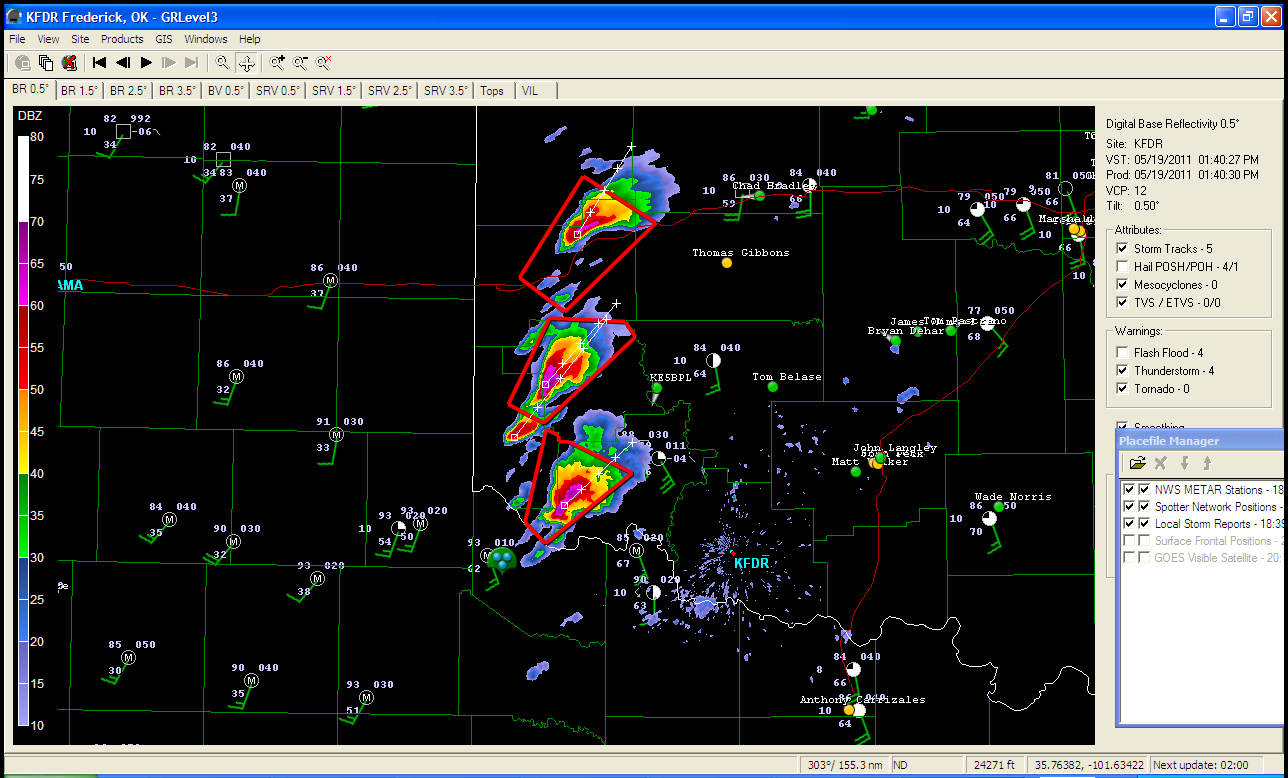
Thursday, May 19, 2011
5/19/11
Well, convection has fired in SW OK along the dryline. Here is the screengrab from GR3 at 19Z:
 Unfortunately I won't be able to make it up there tonight due to work but I'm hoping to catch some tubes on the streams.
Models did well with dryline placement; not too well with convection though. I think the HRRR showed precip firing a little earlier than this closer to the SPS area. The storms are all rotating and are moving NE into a good environment. The dews are in the middle 60's with even 70 dews creeping up from SC OK. Backed sfc flow of 20+ kts and MLCAPE values of over 2500 J/kg, also LCL's below 1200 m all look enticing. 0-1 km shear is pretty weak (10-15 kt) but the environment to the NE of these does get better and the SPC's mesoanalysis shows 0-1 SRH values of 150 in WC and NW OK. The northern-most storm may be the good play at this point if these all stay discrete over time.
We will see.
Tuesday, May 17, 2011
Need to refocus
Haven't posted in a while. Been extremely busy with school stuff and field trips and along with an active April season, i haven't posted chase reports nor posted anything else. So, with potential chase days this week, I better get refocused and get back into the forecast mindset! I will have the opportunity to chase both on the 19th and 20th.
It's 3Z, Wednesday the 18th and here's the synoptic breakdown:

Strong H5 trough along west coast. Will slowly make way towards plains over next couple days.
For Thursday the 19th. Here are the model differences as of 18Z models.
By 18Z, the 19th, the GFS is a bit deeper with H5 low and places 70kt jet streak along W TX and OK panhandles. The GFS is also showing a bit more meridional component to the flow and is a bit east of the NAM jet streak placement.
With the deeper H5 low solution of the GFS, a deeper H85 low is also shown. Flow is near 20kt wwith a strong southerly component (S or SSW). The GFS continues to deepen H85 low and thus strengthens flow to around 30-35kt. NAM is warmer with temps and also mixes these down to surface.
NAM places broad 997mb sfc low in SE CO. A warm front extends east through SW KS and looks to not move through 0Z. Temp gradient is strong with 60's to north and 80's to south of front. GFS has stronger 994mb low in E CO with WF in N KS. Also looks like GFS places meso low in SW KS by 0Z.
Dryline placement similar and placed from Hutchinson down through Wichita Falls with mid 60 dews east of line. Backed sfc flow looks enticing on both models. Temps in warm sector in the mid 70's on GFS and mid 80's on NAM. If GFS is to be believed, then LCL's look good < 1000m.
Will analyze models tomorrow, but the GFS solution looks good but it has tended stronger all season long only to putter out the day before. I believe it has showed run to run consistency though this time. The 700-500mb lapse rates are not strong at all and I wonder what is causing this. Other than that, I wouldn't be surprised to see a good chance for a couple tornadoes in SW OK near the LAW area and to the north. Better shear exists north along the dryline, but I want to stay south due to work restrictions and better moisture and cape profiles.
It's 3Z, Wednesday the 18th and here's the synoptic breakdown:
Strong H5 trough along west coast. Will slowly make way towards plains over next couple days.
For Thursday the 19th. Here are the model differences as of 18Z models.
By 18Z, the 19th, the GFS is a bit deeper with H5 low and places 70kt jet streak along W TX and OK panhandles. The GFS is also showing a bit more meridional component to the flow and is a bit east of the NAM jet streak placement.
With the deeper H5 low solution of the GFS, a deeper H85 low is also shown. Flow is near 20kt wwith a strong southerly component (S or SSW). The GFS continues to deepen H85 low and thus strengthens flow to around 30-35kt. NAM is warmer with temps and also mixes these down to surface.
NAM places broad 997mb sfc low in SE CO. A warm front extends east through SW KS and looks to not move through 0Z. Temp gradient is strong with 60's to north and 80's to south of front. GFS has stronger 994mb low in E CO with WF in N KS. Also looks like GFS places meso low in SW KS by 0Z.
Dryline placement similar and placed from Hutchinson down through Wichita Falls with mid 60 dews east of line. Backed sfc flow looks enticing on both models. Temps in warm sector in the mid 70's on GFS and mid 80's on NAM. If GFS is to be believed, then LCL's look good < 1000m.
Will analyze models tomorrow, but the GFS solution looks good but it has tended stronger all season long only to putter out the day before. I believe it has showed run to run consistency though this time. The 700-500mb lapse rates are not strong at all and I wonder what is causing this. Other than that, I wouldn't be surprised to see a good chance for a couple tornadoes in SW OK near the LAW area and to the north. Better shear exists north along the dryline, but I want to stay south due to work restrictions and better moisture and cape profiles.
Subscribe to:
Posts (Atom)